Satellite Dish Pointing Calculator

Skew details


3. Zoom the map if needed, then click on the exact place where you wish to install the dish. You can also drag the marker to the desired place. The line that shows the direction of the selected satellite will be green, for elevations above 5°, yellow, for elevations between 0°-5°, or red, if the satellite is below the horizon.
Even with a green line, sometimes the satellite isn't visible: for example in an apartment building, if your windows/balconies are on the opposite side from the satellite.
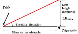
4. But even if you have a window or balcony on the 'good' side of the building, the satellite could still be hidden behind an obstacle: a tree, a nearby building and so on. In that case you can move the mouse cursor (when using a smartphone or tablet just click) on the line that shows the satellite's direction, where it crosses a possible obstacle. A popup window will show the admissible height difference between the dish and the obstacle. (Details)

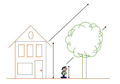
A tree can obstruct the satellite signal, in which case the dish should be installed in a higher position.
If you need to check if a possible obstacle (a tree, a nearby building and so on) will obstruct the signal from the satellite, move the mouse cursor to the point where the line representing the satellite's direction meets the possible obstacle. If using a smartphone or tablet, click on that point.
A popup window will then show the maximum admissible height difference between the dish and the obstacle. (Δhmax)
Most satellite TV transmissions use the so called linear polarisation, which in practice can be either vertical or horizontal. This means that the vector of the electric field of the electromagnetic wave received from the satellite is in a horizontal plane for some frequencies, and in a vertical plane for others. For optimal reception, the receiving antenna should be parallel to the satellite's emitting antenna. This will also ensure that the signals from the other polarity are completely eliminated, since they can be on a nearby frequency or even the same frequency. This possibility of separating signals by polarity practically allows doubling the number of transmissions on a satellite.
But, because satellites are on a circular orbit around the Equator, the vertical (and horizontal) of the satellite are rotated according to the vertical and horizontal at the orbital position of the satellite. For an observer on Earth, only the satellite at the local meridian will have the same vertical and horizontal (for example in London this is approximately the satellite Thor at 0.8°W, for all the other satellites the vertical and horizontal will be tilted, the more so for satellites that are farther to the East, or to the West.
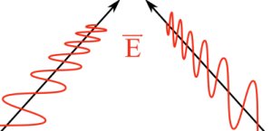
Horizontal and vertical polarisation.
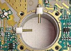
The receiving antenna is in fact located inside the LNB
Actually there are 2 antennas, one for horizontal polarisation, the other one for vertical polarisation.
The following information is for the Northern Hemishpere.
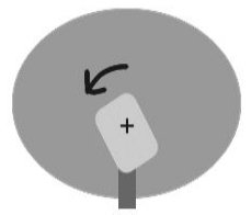
For satellites that are to the West relative to the dish, the skew will be shown as positive, and the LNB should be turned counterclockwise, if facing the dish from the front.
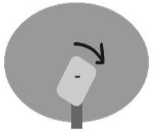
For satellites that are to the East relative to the dish, the skew will be shown as negative, and the LNB should be turned clockwise, if facing the dish from the front.
This is only needed for signals with linear polarisation. For circular polarisation, there is no need to adjust the LNB skew.
For a motorised dish, as the dish moves on its curve in order to receive the satellites, the LNB skew changes for the optimum reception of each satellite.
---
---
